Product Catalog

Hydrophone made in China
WeChat:13580445426
phone:KangXiuHao 13580445426
email:haikangocean@foxmail.com
address:Room 137-141, No. 401, Tianyuan Road, Tianhe District, Guangzhou
GNSS Systems
HOME > PRODUCT > marine geodesy and cartography > GNSS Systems
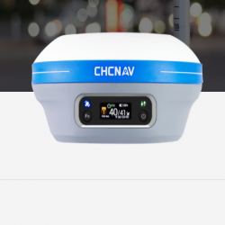
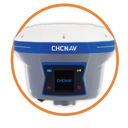
i90 IMU-RTK GNSS GPS Receiver
i90 IMU-RTK GNSS GPS Receiver Full GNSS positioning
Combining GPS, Glonass, Galileo and BeiDou constellations
The embedded 624-channel GNSS technology takes benefit from all GPS, GLONASS, Galileo and BeiDou signals and provides robust RTK position availability and reliability.

Hassle-free IMU-RTK surveying
Dramatically increase RTK availability
No complicated calibration process, rotation, leveling or accessories are necessary with the i90. Just a few meters walk will initialize the i90 internal IMU module and enable RTK survey in difficult field environment.

Extended connectivity
Instant NFC pairing of your controller
The i90 GNSS combines high-end connectivity modules: Bluetooth, Wi-Fi, NFC, 4G, and UHF radio modem. The 4G modem brings ease of use when working within RTK networks. The internal UHF radio modem allows long-distance base-to-rover surveying up to 5 km.

High accuracy. Always
Boost survey and stakeout speed by up to 30%
The i90 GNSS build-in IMU ensures interference-free and automatic pole-tilt compensation in real-time. 3 cm accuracy is achieved with pole-tilt range of up to 30 degrees.
Overview
The i90 GNSS receiver offers integrated IMU-RTK technology to provide a robust and accurate positioning, in any circumstances. Unlike the standard MEMS-based GNSS receivers, the i90 GNSS IMU-RTK combines state-of-the-art GNSS RTK engine, a calibration-free high-end IMU sensor and advanced GNSS tracking capabilities to dramatically increase RTK availability and reliability.
The i90 automatic pole-tilt compensation boosts survey and stakeout speed by up to 30%. Construction and land surveying projects are achieved with high productivity and reliability pushing the boundaries of conventional GNSS RTK survey.
SPECIFICATIONS
Channels
624 channels
Powered by CHCNAV iStar GNSS
tracking technology
Network modem
Integrated 4G modem
LTE (FDD):
B1,B2,B3,B4,B5,B7,B8,B20
DC-HSPA+/HSPA+/HSPA/UMTS:
B1, B2, B5, B8
EDGE/GPRS/GSM
850/900/1800/1900 MHz
GPS L1 C/A, L2C, L2P, L5
Galileo E1, E5a, E5b
SBAS L1
Real time
kinematics (RTK)
Horizontal: 8 mm + 1 ppm RMS
Vertical: 15 mm + 1 ppm RMS
Initialization time: <10 s
Initialization reliability: >99.9%
Data formats
RTCM 2.x, RTCM 3.x,
CMR input / output
HCN, HRC, RINEX 2.11, 3.02
NMEA0183 output
NTRIP Client, NTRIP Caster
Ports
1 x 7-pin LEMO port
(external power, RS-232)
1 x USB Type-C port
(data download, firmware update)
1 x UHF antenna port
(TNC female)
UHF radio
Standard Internal Rx/Tx:
410 - 470 MHz
Transmit Power: 0.5 W to 2 W
Protocol: CHC, Transparent,
TT450, 3AS
Link rate: 9,600 bps to 19,200 bps
Range: Typical 3 km to 5 km
Time to first fix (3)
Cold start: < 45 s
Hot start: < 10 s
Signal re-acquisition: < 1 s
GLONASS L1, L2
BeiDou B1, B2, B3
QZSS L1, L2, L5
Data storage
32 GB internal memory,
Support for removable external
USB/Micro SD to USB Type-C
card reader for data storage and
download
Post-processing
kinematics (PPK)
Horizontal: 2.5 mm + 1 ppm RMS
Vertical: 5 mm + 1 ppm RMS
Bluetooth® V 4.1
Ingress protection
IP67 waterproof and dustproof,
protected from temporary
immersion to depth of 1 m
RTK tilt
-compensated
Additional horizontal pole-tilt
uncertainty typically less than
10 mm + 0.7 mm/° tilt
Environment
Operating: -40°C to +65°C
(-40°F to +149°F)
Storage: -40°C to +85°C
(-40°F to +185°F)
Tilt sensor
Calibration-free IMU for pole-tilt
compensation. Immune to magnetic
disturbances.
E-Bubble leveling
Post-processing static Horizontal: 2.5 mm + 0.5 ppm RMS
Vertical: 5 mm + 0.5 ppm RMS
Autonomous Horizontal: 1.5 m RMS
Vertical: 3 m RMS
Size (L x W x H) 159 mm x 150 mm x 110 mm
(6.3 in × 5.9 in x 4.3 in)
Front panel 4 LED indicates
1.46" OLED Display
Power consumption 5 W
(depending on user settings)
Operating time on
internal battery (4)
UHF receive/transmit (0.5 W):
6 h to 9 h
Cellular receive only: Up to 9 h
Static: Up to 10 h
GNSS Performance (1)
GNSS Accuracies (2)
Hardware
Certification
Electrical
Communication
Code differential
Positioning rate
Shock
Humidity
Horizontal: 0.25 m RMS
Up to 10 Hz
Weight 1.26 kg (2.77 lb)
External power input 9 V DC to 28 V DC
Survive a 2-meter pole drop
100% condensation
Li-ion battery capacity 2 x 3,400 mAh, 7.4 V
本文标签:RTK
上一篇:没有了
下一篇:i83 IMU-RTK GNSS


