
Product Catalog

Hydrophone made in China
WeChat:13580445426
phone:KangXiuHao 13580445426
email:haikangocean@foxmail.com
address:Room 137-141, No. 401, Tianyuan Road, Tianhe District, Guangzhou
unmanned surface vessel
HOME > PRODUCT > marine geodesy and cartography > unmanned surface vessel
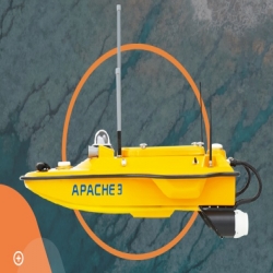
unmanned surface vessel USV APACHE 3
")
The APACHE 3 unmanned surface vessel USV is a portable shallow-draft hull with a single beam echo sounder for bathymetric surveys of lakes, inland rivers, and coastal areas. The master control unit provides seamless 4G communication, removing the limitations of traditional network bridge base stations and transmission distances, making field work easier.
The APACHE 3 USV combines a dual GNSS positioning and heading sensor, a stable and reliable hull attitude and an IMU sensor, allowing uninterrupted survey while passing under bridges. The high efficiency 5 m/s motors and absolute straight-line technology allow a fully automatic pre-determined course in autonomous mode under adverse current and flow conditions.
")
ONE-MAN OPERATION
Made of macromolecule polyester carbon fiber
and Kevlar fiber-glass weighting 7 kg without
sensors. It can be carried by a single person
during the entire project from on-site transport,
installation, calibration, and mission processing.
Allow one operator to cope with most of
remote deployment conditions
HIGH PERFORMANCE POCKET-HULLED VESSEL DESIGN
With less than 1 m length and pocket-hulled vessel
design, the APACHE 3 supports operation in
shoals, channels, and shallow rivers for the
bathymetric survey without run aground.
Keeps the hull balanced even in the rapid
current situation
MAINTAIN HIGH ACCURACY UNDER BRIDGES
The integration of GNSS and IMU sensor
provides accurate position and attitude data to
compensate for hull sway on survey results. The
APACHE 3 provides consistently high accuracy
positions even during temporary GNSS outages
while passing under bridges. Tight integration of
GNSS and INS data eliminates outliers.
Integrated IMU to overcome temporary GNSS
outage
ABSOLUTE LINEAR TECHNOLOGY
Integrate high precision GNSS positioning and
heading technology to ensure high accuracy
bathymetric survey in fully autonomous mode.
Maintain a perfect straight sailing course
even in complex current conditions
MAKE SURVEY POSSIBLE IN MOST WATER CONDITIONS
DC-injection rotary motor technology provides
a 40% increase in energy conversion efficiency.
The motor's high speed (7,000 rpm), its anticollision
design with a sealed straw cover with
oblique titanium alloy mesh and its anti-corrosion
design (resistant to one month's immersion in
sea water) make it extremely durable.
")
")
本文标签:Marine surveying
上一篇:没有了
下一篇:没有了